RIS Feed

Indicator

Changing in Mangrove Protection

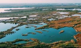
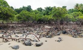
Mangroves forests are a crucial coastal ecosystem in tropics and subtropics countries. They provide a lot of environmental and socio-economic services and they are the main strategy for the resilience of coast areas to climate change impacts.

According to the mangrove forests dataset released in the Global Mangrove Watch Version 3.0, there were 42063, 614 km2 within ACP countries in 2020. The most extensive area of mangroves falls within West Africa region with Nigeria that host around19% of the ACP mangroves.

24416
Indicator

Tidal Marshes Protection

Researcher at The University of Cambridge and global environment nonprofit The Nature Conservancy (TNC) have published a 10 m resolution map of Earth’s tidal marshes


Tidal marshes are productive coastal ecosystems that are important to human wellbeing and biodiversity. Moreover, The marshes store carbon in their soils for millennia, making them crucial contributors to climate change mitigation efforts

These ecosystems have been jeopardised by human activities mainly because of the growth of coastal populations


24379
Indicator

Proportion of total land area that is under cultivation

Cropland is land used for the cultivation of crops. Land change from natural/semi natural ecosystems to agriculture is a major driver of biodiversity loss and land degradation. Efficient land use and land management plans and strategies are needed to maximize crop productivity while minimizing the potential environmental impact due to excessive loss of habitats and overuse of natural resources such as soils and water


24366
Indicator

Percentage of Indigenous People Lands that are protected

Territories and areas that are conserved by indigenous peoples and local communities are called ICCAs that is an abbreviation for the territories and areas conserved by indigenous peoples and local communities. There are several protected areas and other effective area-based conservation measures (OECMs) reported to Protected Planet under the governance of indigenous peoples and local communities. However, a global map of Indigenous Peoples’ land occupation is still missing.

24359
Indicator

African development corridors and their impact on PAs

The African Development Corridors is the first comprehensive database of 79 ongoing and planned investment corridors across Africa, synthesizing data from multiple sources covering 184 projects on railways, wet and dry ports, pipelines, airports, techno-cities, and industrial parks.It was published by Thorn, J.P.R., Bignoli, D.J., Mwangi, B. et al. The African Development Corridors Database: a new tool to assess the impacts of infrastructure investments. Sci Data 9, 679 (2022).

24287
Indicator

Conserving and Protecting Intact Forest Landscapes

An intact forest landscape (IFL) is a seamless mosaic of forest and naturally treeless ecosystems with no remotely detected signs of human activity and a minimum area of 500 km2. (Potapov et al.2017) Intact forests are complex and diverse ecosystems that if lost, are irreplaceable. Research shows that designating intact forest landscapes as protected areas has proven effective at limiting their fragmentation.

24264
Indicator

Tree Cover Change

According to FAO, since 1990, 420 million hectares of forest have been lost due to human pressure, but the rate of forest loss has declined substantially. Human activities such as agriculture, livestock industries and logging are the main drivers of deforestation, forest degradation and fragmentation. Moreover, indirect human pressure such as climate change impacts, fires and invasive species amplify the loss and degradation of these ecosystems. Monitoring forests and their biodiversity is essential to support Sustainable Forest Management.

24219
Indicator

Number of IMET assessments by country

IMET is a Protected Area Management Effectiveness (PAME) tool that allows an in-depth assessment of marine and terrestrial protected areas, regardless of their management categories and governance type. It is also a decision support tool that helps protected area managers take analysis-based management decisions for improved conservation outcomes. 

Typically, the first IMET assessment consists of a 3-4 day workshop with the protected area team and key stakeholders facilitated by one or two IMET coaches.

24215
Indicator

Number of species in Protected Areas

Indicator unit Returns, for each protected area in a country, the number of species (total, near threatened, threatened, endemic, threatened endemic) with range falling within the protected area.

Area of interest Species lists are generated for each terrestrial and coastal protected area and are provided for all protected areas of size ≥ 1 km2.

24196
Indicator

Country extinction-risk footprints

A new study quantified how the consumption habits of people in each country, through trade and supply networks, imperil threatened and near-threatened terrestrial species of amphibians, mammals and birds. For the study, recently published in Scientific Reports, researchers used a metric called the extinction-risk footprint. The team found that 76 countries are net “importers” of this footprint, meaning they drive demand for products that contribute to the decline of endangered species abroad.

23572
X

SIGN IN TO BIOPAMA

Enter your details below.