@Antonio Vecoli

RIS BLOG

News and Events
Ecosystem services assessment in Timor Leste

How much do ecosystem services value and how much of this value is hold in protected areas? Though these questions are very difficult to answer, providing evidence of nature contribution to people and the role of protected areas as sources of values rather than sink is key in the process of conservation endorsement, particularly when monetary value is accounted for. In this report we present ecosystem services evaluation and mapping in Timor-Leste based on two approaches: global monetary value summaries and national experts evaluations. The analysis was conducted at national scale and protected site levels and reveals data gaps, important differences in the outcomes of the two approaches, and overall a very low protection of marine services.

EU-Caribbean Workshop on Marine Scientific Cooperation

Please to know more about this hybrid event: https://eu-caribbean-marine-research.service-facility.eu/

The Caribbean is considered one of the most vulnerable regions in the world to the impacts of climate change, with coastal communities and low-lying areas being particularly exposed to the combined threats of sea level rise and extreme weather events.
Although Science, Technology and Innovation (STI) are key to increase climate resilience, and oceans are fundamental to achieve the Sustainable Development Goals (SDGs) in the region, investment in STI has been relatively low. There is a need to foster marine research within the region as well as to enhance its contribution to global knowledge production and to strengthen the science-policy-society interface.
The objective of the workshop is to gather multiple stakeholders in marine research to discuss on the potentialities, needs and gaps in marine research cooperation for the Caribbean region. Emphasis will be laid on the marine research topics: Coastal resilience, fisheries management, marine protected areas, ecosystems and biodiversity, ocean observation, research infrastructures.


Assessing the social impacts, governance and equity of conservation

Conservation activities entail many relationships between environmental non-governmental organizations and donors, governments and private sectors, practitioners and local people  resulting in what Sundberg (2006) called ‘conservation encounters’ – complex interactions that encompass encounters between the global and local, different cultural and social systems, human and non-human species, powers and ownerships.   https://storymaps.arcgis.com/stories/37d984fa79ca44719c6a8f4bd0aa97b6

Since the Conference on Environment and Development in Rio de Janeiro in 1992, participatory approach to natural resources management has increasingly been recommended and recognised internationally as necessary for improving project goals and their sustainability. In particularly, the contribution of Indigenous People and Local communities (IPLCs) to effective conservation strategies has gained recognition. Several studies have demonstrated that conservation strategies and natural resources management supporting an equitable approach for both people and nature, achieve positive both social and ecological outcomes and contribute to effective long-term conservation of biodiversity

Celebrating Marine Protected Areas - MPAs Day, 1st of August

Marine Protected and Conserved Areas are a cornerstone for conservation of natural and cultural heritage. They provide ecosystem services that are critical for human health and local livelihoods and they are one the major tools to reach biodiversity conservation goals

 https://arcg.is/0P1an4

Marine Protected Areas are fundamental not only to ensure conservation strategies but also to ensure the conservation and protection of traditional culture and the rights of local and indigenous people. The ocean includes marine resources that people use for subsistence, medicinal, and other purposes. They also include intangible cultural resources of spiritual, religious, and historic importance. According to the World Protected Areas Database, over the last years the number of MPAs are increasing quickly. However, it is not enough to ensure biodiversity conservation unless MPAs are properly managed and governed; an inclusive governance plays an important role in delivering social and ecological benefits

From Data to Decision-Making

Data and information on biodiversity state and trends are fundamental to monitor conservation status of world’s ecosystems and to tackle the biodiversity crises we are facing. The availability and reliability of biodiversity data become, in the last decades, the strategic pillar to policy and decision-making process. There is a strong need for biodiversity data and information to better evaluate progress towards conservation goals and to tailor new evidence-based conservation strategies. 


https://storymaps.arcgis.com/stories/2d17ee8c24c945eda4150c261f4d3941

In order to enhance the availability and accessibility of data and knowledge on the state of biodiversity and to promote regional and national engagement to make policy-related data available, the Joint Research Centre (JRC), through the BIOPAMA Programme, has developed a publicly available online platform for supporting policy- and decision-makers to monitor the progress towards conservation goals and to set new targets. Data is crucial for making informed decisions. The BIOPAMA team is committed to ensuring that relevant data and information are readily available for decision-makers and other relevant stakeholders. The Reference Information System (RIS) for Protected Areas of African, Caribbean and Pacific Region is an online information system composed of a suite of map-centric tools aimed at gathering all the best available scientific data on biodiversity conservation and management and at increasing the impact of biodiversity data in decision-making process

Western Indian Ocean islands take over IMET

In the past few weeks, a new wind is blowing for protected and conserved areas management effectiveness in the islands of the Western Indian Ocean. 

Marine Protected Area Managers discover IMET 

Thanks to a collaboration between Varuna Biodiversité, RECOS, the Indian Ocean Commission (IOC), Western Indian Ocean Marine Protected Areas Professional Network (WIOPAN) of the Western Indian Ocean Marine Science Association (WIOMSA) and with the support of BIOPAMA, 40 participants were introduced to IMET on 29th- 30thMarch in Nosy Be island, Madagascar. Participants were from MPAs, government agencies, NGOs, biodiversity funds and support agencies from 7 countries and territories: Comoros, Réunion, Madagascar, Mauritius, Mayotte, Rodrigues and Seychelles. IMET coaches Domoina Rakotobe, Tiana Rahagalala and Arthur Tuda actively led the training which ended with strong interest in the tool. The next steps would be to use IMET in their own institution, and to organize a session on management effectiveness at the first MPA managers network congress scheduled in October.

Madagascar National Parks starts the largest IMET campaign

After having one of their staff trained as an IMET coach in 2022, Madagascar National Parks has launched an ambitious campaign to assess all of its 43 protected areas with IMET this year. The first step, an IMET workshop, was held April 17-21 on the island of Nosy Be, with participation of eight protected areas in northern Madagascar. The particularity of the approach was to combine training and IMET pre-filling. For this first event, Madagascar coaches Liliane Parany (MNP) and Tiana Rahagalala (URI) were supported by COWI’s experts Carlo Paolini and Domoina Rakotobe. Trainee coaches from MNP and the Ministry of Environment were also part of the training team. MNP hopes to produce an IMET scaling-up analysis of its protected areas in the second semester of 2023

IMET version for OECM is tested in two community-based conservation areas in Madagascar

In addition to a test in Sierra Leone in March, a new field test of the OECM version of IMET was conducted in a terrestrial and a marine conservation area in northeastern Madagascar. This new version of IMET aims to facilitate management effectiveness evaluations for sites other than protected areas, particularly community conserved areas. Wildlife Conservation Society (WCS) Madagascar Program supported the initiative, namely through their EU-funded project Sustainable Wildlife Management (SWM). From April 12-16 , 17 participants from the Ambodivoangy Miray community near Makira National Park and 19 participants from Maintimbato LMMA in Antongil Bay evaluated the effectiveness of their site management. Participants reported that IMET helped them better understand strengths and weaknesses of their management, and identify clear recommendations.

Première cohorte de participants de 8 aires protégées des Parcs Nationaux de Madagascar lors de l'atelier de formation-évaluation IMET sur l'île de Nosy Be, Madagascar Participants MNP visitant le parc national de Nosy Tanihely, dans le cadre de la formation Communautés locales gérant l'aire conservée d'Ambodivoangy, dans le nord-est de Madagascar Les participants discutent des priorités de gestion après avoir vu les résultats de l'IMET
Data workshop on Protected and Conserved Areas for Eastern and Southern Africa-Nairobi, 20-24 March 2023

Change is the end result of all true learning

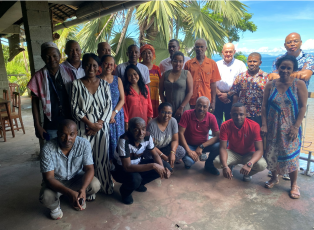
When I accessed the Regional Centre for Mapping Resources for Development headquarter in Kasarani, Nairobi, to attend the second edition of the Regional Resource Hub (RRH) Data Workshop on Protected and Conserved Areas for Eastern and Southern Africa, I could see the change has happened

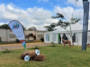
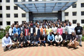
The banners, the reception gazebo, the big statues representing typical wildlife, the large tents hosting the buffets, the large plenary sessions room ready to host more than 70 people from all countries of Eastern and Southern Africa, were all good signs of that. 
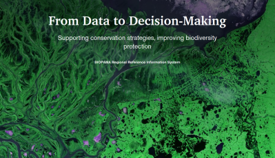
The Regional Resource Hub was created as one of the regional observatories for biodiversity and protected areas under the Biodiversity and Protected Areas Management (BIOPAMA) programme.  The only two years old Regional Resource Hub for Eastern and Southern Africa had definitely grown up to an independent, standing alone secretariat run by a competent, enthusiastic and close-nit team of Kenyans: Ngugi Kimani, Eric Wabwile, Isaac Fadamullah, Yvonne Khaemba and Job Wangi. 

Another big sign of change was when I saw Zakhe Dlamini on the stage. He was a trainee during the first Data Workshop Edition in 2022, representing Eswatini National Trust Commission, but in this edition he even gave a talk on using Data Science to support decision-making. He wanted to share with his peers what could be achieved by using data evidence! Inspired by Zakhi, the training participant Ana Gledis da Conceição, Junior Officer of Research at National Administration of Conservation Areas in Mozambique, declared that in the next edition she would also like to be a speaker.

I trusted this would happen by the end of BIOPAMA program, acknowledging the RRH staff experience and expertise, but I was surprised by the speed at which the RRH took off, particularly since the pandemic has been called off.
The change has happened both in the form and in the substance. This was evident to me as well as to our colleague Falko Buschke- newcomer in BIOPAMA and focal point for Southern Africa- and to our long term project partners Chrstine Mentzel (IUCN ESARO) and Jasmin Upton (UNEP-WCMC), who attended the workshop.
 

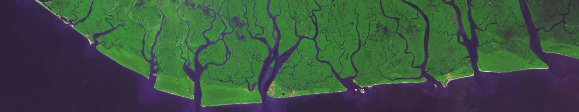
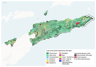
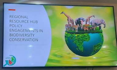
The workshop was the first in the region targeting specifically Biodiversity Conservation and the role of data-evidence for achieving Global Biodiversity Targets for Protected and Conserved Areas, entirely run by an African organisation for a large audience of  African stakeholders. It successfully achieved its major objectives: 
•    to demonstrate and discuss the importance of data and information in decisions related to effectiveness and governance in protected and conserved areas
•    to engage on how the countries will participate in the preparation of the State of Protected and Conserved Areas Report 2023 (SOPACA);
•    to demonstrate the information management process of the RRH; 
•    to allow countries to engage actively with the Regional Reference Information System
•    to demonstrate and discuss the role the RRH can play in reporting processes, for e.g., to the Convention on Biological Diversity (CBD)
•    to understand what the interest and needs of users and potential users in the countries are; 
•    to allow the RRH team to improve the services and products available; 
•    to launch the RRH community of practice
•    to learn about some existing opportunities under Conservation Programs run by various institutions like Esri, Planet 

Claudia Capitani (Project Officer - BIOPAMA East Africa focal point)

IMET assessments in the Tai, Grebo-Khran and Sapo NP

In 2021, the Ivorian Office of Parks and Reserves (OIPR), the Liberian Forest Department Authority (FDA) and the German cooperation agency GIZ evaluated the three parks: Tai, Grebo-Khran and Sapo with the  Integrated Management Effectiveness Tool (IMET) . The overall objective was to identify strengths and weaknesses of management. In each park, a dozen of participants from staff, local stakeholders and partners spent four days to look at all aspects of park management taking into account the local context and history of each park. 

Thanks to IMET scaling-up function, they were able to compare and carried out more in-depth analysis among the three parks.


See our StoryMap: 


https://rris.biopama.org/biopama_stories/sustainable-landscapes-post-crisis-times


Effectively managed protected areas are crucial for safeguarding critical biodiversity and habitats and providing many benefits to human well-being and wildlife. The Integrated Management Effectiveness Tool (IMET) ultimate goal is to improve decision making for protected area management, operation, and planning. IMET has internal statistics analysis and generates visualization aids that give a quick overview of the quality of management. 

To learn more about IMET check our dedicated page https://rris.biopama.org/pame/. It can be downloaded from the same page . Once downloaded, it can be used without Internet connection. The IMET Handbook, called COMIT, is available in  French and  English . ​

Validation Workshop of the Observatory for Biodiversity and Protected Areas In West Africa

The validation workshop of the observatory for biodiversity and protected areas in West Africa has been held in Dakar on 14-17 March. The event was a fundamental step for the official recognition of the West Africa regional observatory. 
 

The West Africa Economic and Monetary Union (Waemu) convened representatives of the 16 countries of the region to discuss about the results of the first 2 years of implementation of the West Africa Observatory for Protected Areas and biodiversity (OBAPAO) and the way forward. 
 

Biodiversity and protected areas experts of west African countries beneficiary of the BIOPAMA, PAPBIO and PAPFOR programs, Technical Director and the Experts of the CSE, Regional Director and IUCN BIOPAMA expert, Representative of the Delegation of the European Union to Senegal, Experts from the Joint Research Centre of the European Commission, Expert from the VITO Design Office, ECOWAS Expert, Regional Coordinators of the PAPBIO and PAPFOR programs and Representative and experts from the UEMOA Commission met in presence for a review and validation workshop for progress carried out as part of the establishment and operationalization of the Observatory 

The OBAPAO observatory encourages the dissemination of relevant scientific data and knowledge on biodiversity to support decision-making and enhances the capacity of key stakeholders in data collection and sharing, and builds capacities to assess PAs management effectiveness. 

The Regional Reference Information System (RRIS) is one of the main pillars of the observatory work, enhancing the availability and accessibility of data and knowledge on the state of biodiversity and to promote regional and national engagement to make policy-related data available. The RRIS is an online information system composed of a suite of map-centric tools aimed at gathering all the best available scientific data on biodiversity conservation and management and at increasing the impact of biodiversity data in decision-making processes. 

Please check OBAPAO RRIS, you can find maps, reports, data and other relevant information on the status of biodiversity and protected areas that you can download and use as needed: www.obapao.org

Mangrove Protection by Governance Type in ACP countries

Protected and Conserved Areas are a cornerstone for conservation of natural and cultural heritage. They provide ecosystem services that are critical for human health and local livelihoods and they are one the major tools to reach biodiversity conservation goals. The increase in areas under protection is a great result. It is not enough to ensure biodiversity conservation unless PAs are properly managed and governed.
 

Many studies suggest that inclusive governance plays an important role in delivering social and ecological benefits. The International Union for Conservation of Nature (IUCN) recognizes four protected area governance types: Governance by government; Shared governance; Private governance and Governance by indigenous peoples and local communities with respect to who holds decision-making and management authority and responsibility about protected areas.

Differences among protected area governance types matter for conservation outcomes. We analysed the change in mangrove forests cover among different types of protected areas governance. We used the dataset for mangrove forests cover provided by Bunting et al. (2022) to estimate the effort to protect mangrove forest by ACP countries and the rate of loss within protected areas grouped by governance and countries between 2007-2020.


Made with Flourish 
 

In 2020, around 38% (about 16000 km2) of mangrove forests in ACP countries were covered by more than 2000 protected areas.  54% of those protected areas are managed by government authorities while 6.6% have a shared governance and 9,8 % are managed by Indigenous People and Local Communities. The remaining 24% has a ‘ not reported’ governance in the World Database of Protected Areas (WDPA).

The overall effort of ACP countries to protect mangrove forests has increased up to 41% between 2007-2020. Most of these areas are managed by government authorities but areas governed by Indigenous people and local communities  rise up to 198 in 2020.

To have these metrics at country level, please check BIOPAMA Geonode: https://geonode-rris.biopama.org/layers/geonode:geonode_man_prot_2020#


Analysis performed by Simona Lippi and Andrea Capata


Source data

Bunting, P.; Rosenqvist, A.; Hilarides, L.; Lucas, R.M.; Thomas, T.; Tadono, T.; Worthington, T.A.; Spalding, M.; Murray, N.J.; Rebelo, L-M. Global Mangrove Extent Change 1996 – 2020: Global Mangrove Watch Version 3.0. Remote Sensing. 2022


Made with Flourish
X

SIGN IN TO BIOPAMA

Enter your details below.